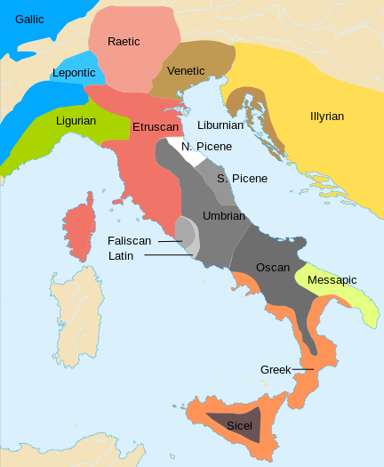
File:Iron Age Italy.svg

Size of this PNG preview of this SVG file: 432 × 525 pixels. Other resolutions: 197 × 240 pixels | 395 × 480 pixels | 632 × 768 pixels | 843 × 1,024 pixels | 1,685 × 2,048 pixels.
Original file (SVG file, nominally 432 × 525 pixels, file size: 271 KB)
File history
Click on a date/time to view the file as it appeared at that time.
| Date/Time | Thumbnail | Dimensions | User | Comment | |
|---|---|---|---|---|---|
| current | 23:20, 1 December 2013 |  | 432 × 525 (271 KB) | Enok | Reverted to version as of 03:06, 10 September 2013 - No source on Sardinia |
| 17:18, 13 November 2013 |  | 432 × 525 (241 KB) | Felisopus | Reverted to version as of 13:50, 22 May 2013; sources already provided. whole map have peculiar unsourced boundaries | |
| 03:06, 10 September 2013 |  | 432 × 525 (271 KB) | Enok | Reverted to version as of 13:00, 22 December 2012 - no source on Sardinia | |
| 13:50, 22 May 2013 |  | 432 × 525 (241 KB) | JBW | Disambiguating name | |
| 08:34, 6 January 2013 |  | 432 × 525 (232 KB) | Felisopus | Reverted to version as of 11:20, 2 October 2012. no reason given, Category:Phoenicians in Sardinia | |
| 13:00, 22 December 2012 |  | 432 × 525 (271 KB) | Enok | Reverted to version as of 14:58, 7 February 2011 | |
| 11:20, 2 October 2012 |  | 432 × 525 (232 KB) | Felisopus | Reverted, rb. This map is called "Iron Age". this division of the island is present in all sources, http://it.wikipedia.org/wiki/File:LimesNuragiciPunici.JPG | |
| 01:42, 26 September 2012 |  | 432 × 525 (271 KB) | Enok | Reverted to version as of 14:58, 7 February 2011 (Unsourced) | |
| 00:54, 24 September 2012 |  | 432 × 525 (304 KB) | Daygum | Not punics in Sardinia in the Bronze Age, and the later punic presence was probably limited to the coasts, because there aren't sources to establish if punic was really widely spoken. | |
| 00:50, 24 September 2012 |  | 432 × 525 (271 KB) | Daygum | Reverted to version as of 14:58, 7 February 2011 |
File usage
The following page uses this file:
Global file usage
The following other wikis use this file:
- Usage on af.wikipedia.org
- Usage on an.wikipedia.org
- Usage on ar.wikipedia.org
- Usage on arz.wikipedia.org
- Usage on azb.wikipedia.org
- Usage on az.wikipedia.org
- Usage on be-tarask.wikipedia.org
- Usage on be.wikipedia.org
- Usage on br.wikipedia.org
- Usage on ca.wikipedia.org
- Usage on cs.wikipedia.org
- Usage on cy.wikipedia.org
- Usage on da.wikipedia.org
- Usage on de.wikipedia.org
- Usage on el.wikipedia.org
- Usage on en.wikipedia.org
- Magna Graecia
- Umbrian language
- Osci
- Adriatic Veneti
- Ligures
- Messapic language
- Venetic language
- List of historical states of Italy
- Languages of Italy
- Osco-Umbrian languages
- Picenum
- Italic peoples
- Umbri
- Liburnia
- Liburnians
- Liburnian language
- History of Latin
- South Picene language
- North Picene language
- Military history of Italy
- Insubres
- Picentes
View more global usage of this file.


