File:France cities.svg

Size of this PNG preview of this SVG file: 600 × 600 pixels. Other resolutions: 240 × 240 pixels | 480 × 480 pixels | 768 × 768 pixels | 1,025 × 1,024 pixels | 2,049 × 2,048 pixels | 1,797 × 1,796 pixels.
Original file (SVG file, nominally 1,797 × 1,796 pixels, file size: 383 KB)
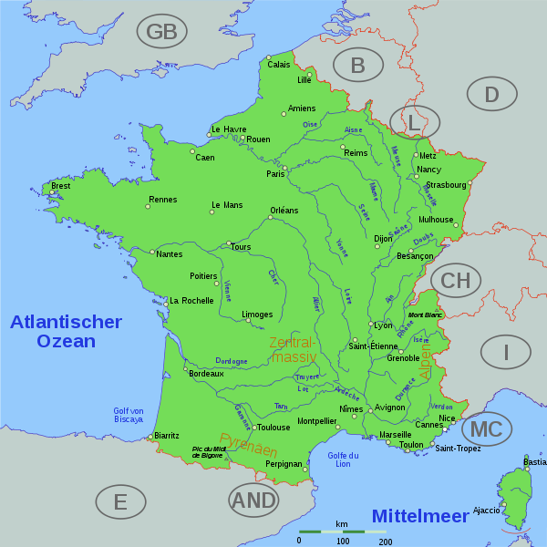
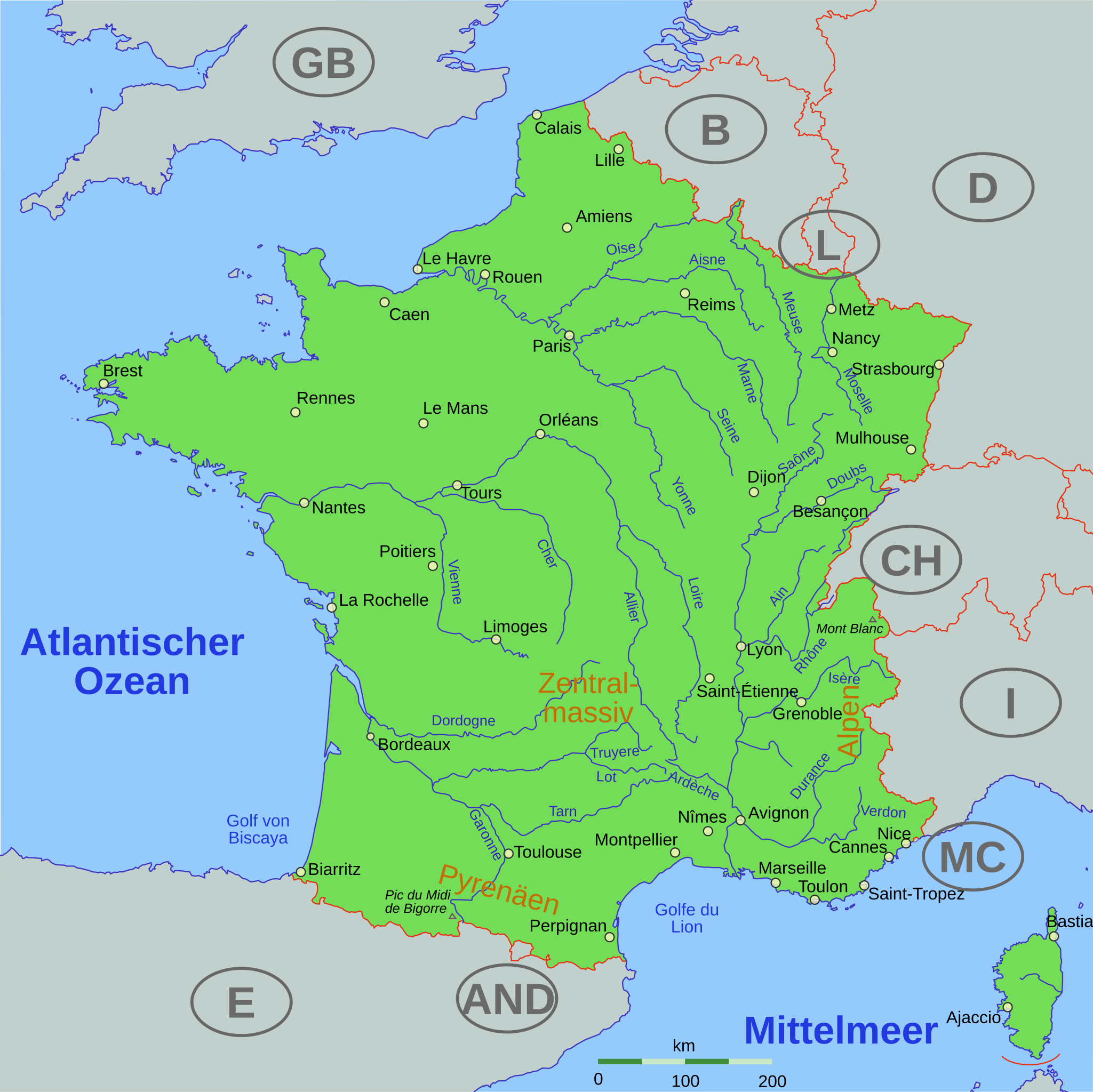
| Description | map of France with cities and rivers |
| Date | |
| Source | inkscape and the files below helped me. if you edit it: be aware of the fact that I added some CSS by hand (cities, ...) |
| Author | Thomas Steiner |
| Permission (Reusing this file) |
Thomas Steiner put it under the CC-by-SA 2.5. |
| Other versions |
Derivative works of this file: Level 3 network France.svg Image:France_cities.png, Image:Cotedazur.png |
This file is licensed under the Creative Commons Attribution-Share Alike 2.5 Generic license.
- You are free:
- to share – to copy, distribute and transmit the work
- to remix – to adapt the work
- Under the following conditions:
- attribution – You must give appropriate credit, provide a link to the license, and indicate if changes were made. You may do so in any reasonable manner, but not in any way that suggests the licensor endorses you or your use.
- share alike – If you remix, transform, or build upon the material, you must distribute your contributions under the same or compatible license as the original.
File history
Click on a date/time to view the file as it appeared at that time.
| Date/Time | Thumbnail | Dimensions | User | Comment | |
|---|---|---|---|---|---|
| current | 08:43, 23 September 2006 | | 1,797 × 1,796 (383 KB) | Thire | no far away countries, bigger cities, tried css, minor things, cher, ... |
| 07:14, 20 September 2006 |  | 1,797 × 1,796 (366 KB) | Thire | now plain svg, not inkscape (thanks fZap at www.inkscape-forum.de) | |
| 16:41, 19 September 2006 |  | 1,797 × 1,796 (384 KB) | Thire | countrynames, NL rivers | |
| 07:01, 19 September 2006 |  | 1,797 × 1,796 (385 KB) | Thire | typo: Pyrenäen | |
| 06:58, 19 September 2006 |  | 1,797 × 1,796 (385 KB) | Thire | grey other countries, rivers just in france, mountains, details, ... | |
| 16:55, 17 September 2006 |  | 1,797 × 1,796 (349 KB) | Thire | {{Information| |Description = map of France with cities and rivers |Source = inkscape and the files below helped me. if you edit it: be aware of the fact that I added some CSS by hand (cities, ...) |Date = 17 sep. 2006 |Author = [[:de:Benutzer:Thire|Thoma |
File usage
The following page uses this file:
Global file usage
The following other wikis use this file:
- Usage on bg.wikipedia.org
- Usage on da.wikipedia.org
- Usage on de.wikipedia.org
- Usage on hu.wikipedia.org
- Usage on qu.wikipedia.org
- Usage on uk.wikipedia.org