Sõngr sẽn yaa zaalem n yit Wikipedia pʋgẽ
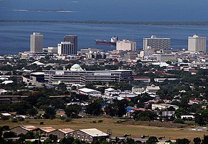
Kingston
| Inception | 1692 |
|---|---|
| Official name | Kingston |
| Native label | Kingston |
| Named after | Kingston upon Thames |
| Demonym | Kingstonien, Kingstonienne |
| Motto text | A city which hath foundations |
| Country | Jamaica |
| Capital of | Jamaica, Colony of Jamaica, Surrey County |
| Located in the administrative territorial entity | Surrey County |
| Located in time zone | UTC−05:00 |
| Located in or next to body of water | Caribbean Sea |
| Coordinate location | 17°58′17″N 76°47′35″W |
| Office held by head of government | mayor of Kingston |
| Member of | Creative Cities Network |
| Shares border with | Portmore |
| Official website | http://www.ksac.gov.jm/ |
| Category for maps | Category:Maps of Kingston, Jamaica |

Kingston yaa Jamaica na-tẽnga la a yaa tẽng sẽn yaa kãseng n yɩɩdã b be tẽn-kãng wĩing-rʋʋng-dʋʋgã sẽn be zĩ-kãsengã rɩtg zug. A yaa tẽn-kãseng sẽn be Palisado wã sẽn kogend tẽngã la Norman Manley International Airport n-taag tẽngã ko-gũb-tẽng wã.
