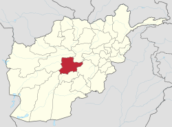
صوبہ دایکندی ( لاطینی: Daykundi Province) افغانستانو ای رہائشی علاقہ شیر۔ [1]
|
صوبہ | |
 An AH-64 Apache helicopter shoots flares over a valley to support members of the 8th Commando Kandak and coalition special operations forces during a firefight near Nawa Garay village, Kajran district in April 2012. | |
 Map of Afghanistan with Daykundi highlighted | |
| ملک | افغانستان |
| قیام | 2004 |
| پایہ تخت | نیلی |
| Government | |
| • گورنر | عبدالحق شفق |
| Area | |
| • Total | 18,088 km2 (6,984 sq mi) |
| Population (2012) | |
| • Total | 438,500 |
| • Density | 24/km2 (63/sq mi) |
| Time zone | UTC+4:30 |
| ISO 3166 code | AF-DAY |
| اہم زبان |
فارسی زبان (ہزارگی زبان اور دری لہجہ) پشتو زبان |
| Website | http://daikundi.gov.af/ |
تفصیلات
editصوبہ دایکندیو رقبہ 18,088 مربع کیلومیٹر شیر، وا ھمو مجموعی آبادی 438,500 رویان سورا مشتمل شیر۔
مزید
editحوالہ جات
edit- ↑ انگریزی ویکیپیڈیا. "Daykundi Province".