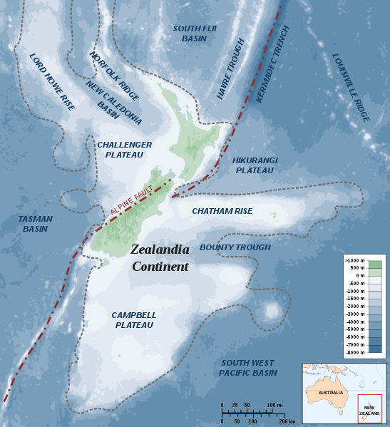
File:Zealandia-Continent map en.svg

Size of this PNG preview of this SVG file: 547 × 599 pixels. Other resolutions: 219 × 240 pixels | 438 × 480 pixels | 701 × 768 pixels | 935 × 1,024 pixels | 1,870 × 2,048 pixels | 789 × 864 pixels.
Original file (SVG file, nominally 789 × 864 pixels, file size: 327 KB)
File history
Click on a date/time to view the file as it appeared at that time.
| Date/Time | Thumbnail | Dimensions | User | Comment | |
|---|---|---|---|---|---|
| current | 22:37, 19 July 2010 |  | 789 × 864 (327 KB) | Beao | Removed border. |
| 11:59, 1 June 2009 |  | 797 × 871 (375 KB) | Alexrk | Removed Grid | |
| 14:19, 20 January 2008 |  | 797 × 871 (380 KB) | Alexrk | ||
| 14:10, 20 January 2008 |  | 797 × 871 (380 KB) | Alexrk | ||
| 16:44, 19 January 2008 |  | 797 × 871 (380 KB) | Alexrk | ||
| 15:55, 19 January 2008 |  | 797 × 871 (380 KB) | Alexrk | ||
| 15:52, 19 January 2008 |  | 1,000 × 1,000 (380 KB) | Alexrk | == Summary == {{Information |Description=Map of the Zealandia Continent |Source=Own work<br/>Bathymetry: ETOPO2v2 2min - vectorized with Inkscape, Land Information New Zealand, Te Ara The Encyclopedia of New Zealand |Date=Jan 2008 |Date=J |
File usage
The following page uses this file:
Global file usage
The following other wikis use this file:
- Usage on af.wikipedia.org
- Usage on ang.wikipedia.org
- Usage on ast.wikipedia.org
- Usage on ca.wikipedia.org
- Usage on ceb.wikipedia.org
- Usage on cs.wikipedia.org
- Usage on de.wikipedia.org
- Usage on en.wikipedia.org
- Geography of New Zealand
- Hikurangi Trough
- Alpine Fault
- Portal:New Zealand
- Metanephrops challengeri
- User:Epipelagic/sandbox/sources
- Volcanism of New Zealand
- Hikurangi Plateau
- Puysegur Trench
- Talk:Zealandia
- Fishing industry in New Zealand
- Geology of New Zealand
- List of submarine topographical features
- Wikipedia:Reference desk/Archives/Science/2015 May 26
- Usage on eo.wikipedia.org
- Usage on es.wikipedia.org
- Usage on hi.wikipedia.org
- Usage on hu.wikipedia.org
- Usage on hy.wikipedia.org
- Usage on id.wikipedia.org
- Usage on it.wikipedia.org
- Usage on ja.wikipedia.org
- Usage on ka.wikipedia.org
- Usage on nl.wikipedia.org
View more global usage of this file.


