File:Venezuela Zulia location map.svg

Original file (SVG file, nominally 512 × 684 pixels, file size: 2.88 MB)
Summary
![]() This SVG map is part of a locator map series applying the widespread location map scheme. Please see root category to browse for more.
This SVG map is part of a locator map series applying the widespread location map scheme. Please see root category to browse for more.
.svg)
.svg)
.svg)
.svg)
.svg)
.svg)
.svg)
Locator maps design recommendations ▼ | |
|---|---|
Principles
Design Guidelines are based on ▸location map design of the German map shop (in German). It's preferable to derive new locator maps from existing location maps. Please keep both size and ratio in this case. Thus the new locator maps may still be applied as location map (▸Guide). Marker color is supposed to be darkred. Waterbodies may be transparent, to show other objects better. Please be aware that this guide is only a recommendation. It’s not an inevitable law!
Highlight small areas
“Remote” areas and mini maps
Mini maps show where the depicted area actually is situated. Check out ▸Vorlage:Positionskarte+ (in German) and ▸Modèle:Carte en coin (in French) of how to insert a mini map in virtually every map.
Disputed areas
Greyed special objects
Backgrounds
|

-en.svg)

.svg)
.svg)
.svg)

_(US48).svg)
_(small_islands_magnified)_(-mini_map_-rivers).svg)
.svg)
_(extra_close)_(US48).svg)
.svg)
_(zoom).svg)

.svg)


_(UNMIK).svg)
.svg)
_(disputed_hatched).svg)
_(claimed_and_disputed_hatched).svg)
.svg)
.svg)
_(%2Ball_claims_hatched).svg)

.svg)
_(shade).svg)
_(shade)_(special_marker).svg)
_(-mini_map).svg)
_(-mini_map).svg)
_(-mini_map).svg)


.svg)

.svg)
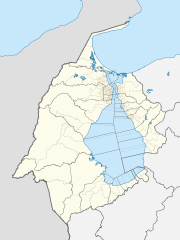
Map legend
- FDFBEA → Marked territory
- F2F2F2 → Other state/provinces of Venezuela
- DFDFDF → Other countries
- 656564 → Lines/boundaries
- C6AF8B → Urban areas (25% transparency)
- C7E7FB → Waterbodies
- 1278AB → Waterbodies border
Geographic limits of the map (EPSG:4326)
- N: 12.2173
- S: 8.0935
- W: 73.5720
- E: 70.4371
Licensing
| Description |
English: Locator map of Zulia, Venezuela |
|||||||||
| SVG development | This map was created with Adobe Illustrator. |
|||||||||
| Date | ||||||||||
| Source | OpenStreetMap data, extracted via QGIS software. | |||||||||
| Creator |
OpenStreetMap contributors |
|||||||||
| Permission (Reusing this file) |
OpenStreetMap data is available under the Open Database License (details). Standard style map tiles are licensed as ODbL Produced Works.
|
|||||||||
| Geotemporal data | ||||||||||
| Bounding box |
|
|||||||||
File history
Click on a date/time to view the file as it appeared at that time.
| Date/Time | Thumbnail | Dimensions | User | Comment | |
|---|---|---|---|---|---|
| current | 14:38, 30 September 2023 | | 512 × 684 (2.88 MB) | Wguayana | OpenStreetMap 2023 data |
| 13:34, 18 August 2015 |  | 1,744 × 2,219 (520 KB) | Milenioscuro | Correciones en la Guajira y en los límites estatales | |
| 05:47, 18 August 2015 |  | 1,742 × 2,216 (519 KB) | Milenioscuro | mejoras | |
| 05:20, 18 August 2015 |  | 1,742 × 2,216 (518 KB) | Milenioscuro | User created page with UploadWizard |
File usage
There are no pages that use this file.
Global file usage
The following other wikis use this file:
- Usage on de.wikipedia.org
- Usage on eo.wikipedia.org
- Usage on es.wikipedia.org
- Maracaibo
- Cabimas
- Combate naval del lago de Maracaibo
- Ciudad Ojeda
- Concepción (Zulia)
- Santa Rita (Zulia)
- Machiques
- San Rafael de El Moján
- Puerto Escondido (Zulia)
- Santa Bárbara del Zulia
- Bobures
- San Carlos del Zulia
- Sinamaica
- Monte Pío
- El Mene
- Barrancas (Santa Rita)
- Palmarejo
- Los Puertos de Altagracia
- Lagunillas (Zulia)
- Castilletes
- Bachaquero
- San Timoteo
- Isla de Toas
- Isla de Zapara
- Península de San Carlos
- Ancón de Iturre
- Mene Grande
- Isla de Pescadores (Venezuela)
- Isla de Providencia (Venezuela)
- Isla Los Pájaros
- Punta Iguana
- Ceuta (Zulia)
- Santa María de Heras
- El Toro (Zulia)
- El Guanábano
View more global usage of this file.