File:Van EQ intensity USGS.jpg
Size of this preview: 510 × 599 pixels. Other resolutions: 204 × 240 pixels | 612 × 719 pixels.
Original file (612 × 719 pixels, file size: 137 KB, MIME type: image/jpeg)
Summary
| Description |
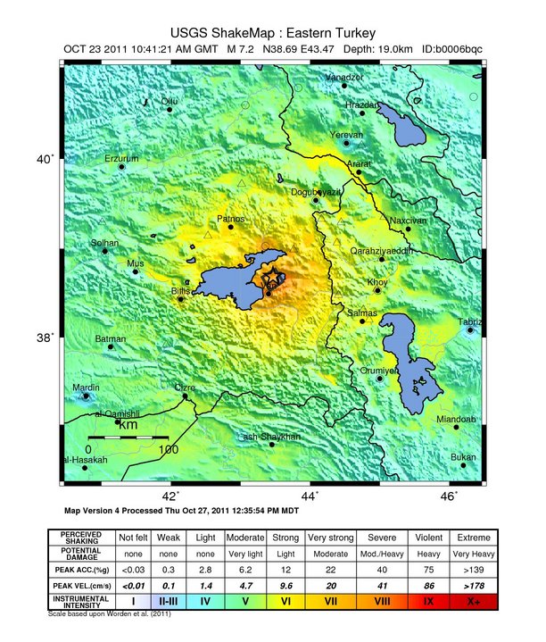
English: Shake map for the 2011 Van earthquake in eastern Turkey |
| Date | |
| Source | USGS webpage [1] |
| Author | USGS |
Licensing
This image is in the public domain in the United States because it only contains materials that originally came from the United States Geological Survey, an agency of the United States Department of the Interior. For more information, see the official USGS copyright policy.
|
File history
Click on a date/time to view the file as it appeared at that time.
| Date/Time | Thumbnail | Dimensions | User | Comment | |
|---|---|---|---|---|---|
| current | 13:59, 28 October 2011 | | 612 × 719 (137 KB) | Haffman | new version |
| 15:46, 24 October 2011 |  | 612 × 719 (137 KB) | Michael Metzger | Corrected and updated ShakeMap of Van earthquake | |
| 14:30, 23 October 2011 |  | 612 × 719 (136 KB) | Mikenorton |
File usage
The following 3 pages use this file:
Global file usage
The following other wikis use this file:
- Usage on ar.wikipedia.org
- Usage on be.wikipedia.org
- Usage on ca.wikipedia.org
- Usage on ckb.wikipedia.org
- Usage on cs.wikipedia.org
- Usage on de.wikipedia.org
- Usage on en.wikipedia.org
- Usage on et.wikipedia.org
- Usage on fa.wikipedia.org
- Usage on fr.wikipedia.org
- Usage on he.wikipedia.org
- Usage on hr.wikipedia.org
- Usage on it.wikipedia.org
- Usage on kk.wikipedia.org
- Usage on ko.wikipedia.org
- Usage on ku.wikipedia.org
- Usage on mk.wikipedia.org
- Usage on ms.wikipedia.org
- Usage on nl.wikipedia.org
- Usage on nn.wikipedia.org
- Usage on pl.wikipedia.org
- Usage on pt.wikipedia.org
- Usage on ru.wikipedia.org
- Usage on sv.wikipedia.org
- Usage on ta.wikinews.org
- Usage on th.wikipedia.org
- Usage on tl.wikipedia.org
- Usage on tr.wikipedia.org
- Usage on tr.wikinews.org
- Usage on uk.wikipedia.org
- Usage on vi.wikipedia.org
- Usage on zh.wikipedia.org