File:Reliefkarte Tauber.jpg

Size of this preview: 717 × 600 pixels. Other resolutions: 287 × 240 pixels | 574 × 480 pixels | 918 × 768 pixels | 1,224 × 1,024 pixels | 2,364 × 1,978 pixels.
Original file (2,364 × 1,978 pixels, file size: 2.82 MB, MIME type: image/jpeg)
Summary
| Description |
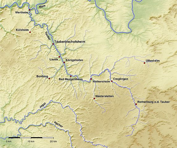
Deutsch: Verlauf des Flusses Tauber und viele kleinere und größere Nebenbäche. English: Map of the river Tauber including many tributaries |
| Date | |
| Source |
Reliefkarte aus SRTM-Daten. Flussverläufe erstellt mit Quantum GIS unter Verwendung von SRTM-Daten. Gesamte Karte erstellt mit Generic Mapping Tools |
| Author | Bernd Haynold |
Licensing
BerndH at the German-language Wikipedia, the copyright holder of this work, hereby publishes it under the following license:

|
Permission is granted to copy, distribute and/or modify this document under the terms of the GNU Free Documentation License, Version 1.2 or any later version published by the Free Software Foundation; with no Invariant Sections, no Front-Cover Texts, and no Back-Cover Texts. A copy of the license is included in the section entitled GNU Free Documentation License. |
| This file is licensed under the Creative Commons Attribution-Share Alike 3.0 Unported license. | ||
| Attribution: BerndH | ||
| ||
| This licensing tag was added to this file as part of the GFDL licensing update. |
Original upload log
Transferred from de.wikipedia to Commons by Rosenzweig using CommonsHelper.
The original description page was here. All following user names refer to de.wikipedia.
- 2009-02-15 18:03 BerndH 2364×1978× (2959640 bytes) {{Information |Beschreibung = Verlauf des Flusses Tauber und viele kleinere und größere Nebenbäche. |Quelle = Reliefkarte aus SRTM-Daten.<br />Flussverläufe erstellt mit Quantum GIS unter Verwendung von SRTM-Daten.<br />Gesamte Karte erstellt mit Gene
File history
Click on a date/time to view the file as it appeared at that time.
| Date/Time | Thumbnail | Dimensions | User | Comment | |
|---|---|---|---|---|---|
| current | 19:52, 22 February 2009 | | 2,364 × 1,978 (2.82 MB) | File Upload Bot (Magnus Manske) | {{BotMoveToCommons|de.wikipedia|year={{subst:CURRENTYEAR}}|month={{subst:CURRENTMONTHNAME}}|day={{subst:CURRENTDAY}}}} {{Information |Description={{de|Verlauf des Flusses Tauber und viele kleinere und gröÃere Nebenbäche.}} |Source=Transferred fr |
File usage
The following page uses this file:
Global file usage
The following other wikis use this file:
- Usage on cs.wikipedia.org
- Usage on de.wikipedia.org
- Usage on de.wiktionary.org
- Usage on eo.wikipedia.org
- Usage on es.wikipedia.org
- Usage on fr.wikipedia.org
- Usage on lv.wikipedia.org
- Usage on nl.wikipedia.org
- Usage on ru.wikipedia.org
- Usage on sv.wikipedia.org
- Usage on www.wikidata.org