File:Prussian clans 13th century.png

Original file (900 × 634 pixels, file size: 353 KB, MIME type: image/png)
Summary
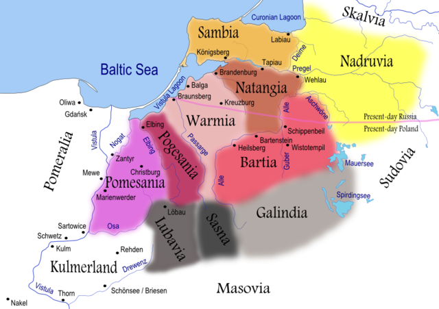
| Description | Map of Prussian clans during the 13th century. Areas shaded in grey reached further south than shown on this map. Prussian clans of Galindians, Sudovians, Sasna and Lubavia as well as Kulmerland had become subjected to numerous incursions and conquests by recently arriving Slavs. |
| Date | |
| Source | Self-made using Inkscape (see below for full discussion) |
| Author | Renata3 |
| Other versions |
|
For background I used: Image:LithuaniaPhysicalMap-Clean.svg by user:Knutux. For consistency, German names were used for cities/castles, rivers and lakes. Tribes/clans were named by their most common English names. Note that all boundaries (including rivers and lakes) are approximate. Shoreline was depicted as it is today (it has changed significantly from the 13th century).
Sources:
- Main: Map used to illustrate article on Prussians in Encyclopedia Lithuanica, volume IV, page 367. It generally agrees with Map by Marija Gimbutas published in The Balts (1963).
- Other: Map from National Museum of Lithuania and maps presented in William Urban (2000). The Prussian Crusade, ISBN 0-929700-28-7
A quite different map is presented in Bojtár, Endre (1999). Foreword to the Past: A Cultural History of the Baltic People. CEU Press, 159. ISBN 963-9116-42-4
Licensing

|
Permission is granted to copy, distribute and/or modify this document under the terms of the GNU Free Documentation License, Version 1.2 or any later version published by the Free Software Foundation; with no Invariant Sections, no Front-Cover Texts, and no Back-Cover Texts. A copy of the license is included in the section entitled GNU Free Documentation License. |
| This file is licensed under the Creative Commons Attribution-Share Alike 3.0 Unported license. | ||
| Attribution: I, Renata3 | ||
| ||
| This licensing tag was added to this file as part of the GFDL licensing update. |
- You are free:
- to share – to copy, distribute and transmit the work
- to remix – to adapt the work
- Under the following conditions:
- attribution – You must give appropriate credit, provide a link to the license, and indicate if changes were made. You may do so in any reasonable manner, but not in any way that suggests the licensor endorses you or your use.
- share alike – If you remix, transform, or build upon the material, you must distribute your contributions under the same or compatible license as the original.
File history
Click on a date/time to view the file as it appeared at that time.
| Date/Time | Thumbnail | Dimensions | User | Comment | |
|---|---|---|---|---|---|
| current | 20:38, 6 April 2008 | | 900 × 634 (353 KB) | Renata3 | resolution |
| 20:35, 6 April 2008 |  | 529 × 372 (159 KB) | Renata3 | masovia | |
| 22:55, 15 July 2007 |  | 991 × 713 (399 KB) | Renata3 | change colors and name for Sasna | |
| 18:34, 14 July 2007 |  | 1,012 × 728 (412 KB) | Renata3 | er... reduce size | |
| 18:31, 14 July 2007 |  | 2,029 × 1,455 (1.08 MB) | Renata3 | add more river names, insculde Sassen | |
| 00:43, 11 June 2007 |  | 989 × 722 (387 KB) | Renata3 | {{Information |Description=Map of Prussian clans during the 13th century |Source=Self-made using Inkscape |Date=2007-07-10 |Author= Renata3 }} For background I used: Image:LithuaniaPhysicalMap-Clean.svg by user:Knutux. Sources |
File usage
The following page uses this file:
Global file usage
The following other wikis use this file:
- Usage on an.wikipedia.org
- Usage on ar.wikipedia.org
- Usage on bat-smg.wikipedia.org
- Usage on ba.wikipedia.org
- Usage on be-tarask.wikipedia.org
- Usage on be.wikipedia.org
- Usage on bg.wikipedia.org
- Usage on ca.wikipedia.org
- Usage on ce.wikipedia.org
- Usage on csb.wikipedia.org
- Usage on cs.wikipedia.org
- Usage on da.wikipedia.org
- Usage on dsb.wikipedia.org
- Usage on el.wikipedia.org
- Usage on en.wikipedia.org
View more global usage of this file.