File:Political map of Canada it.svg

Size of this PNG preview of this SVG file: 512 × 443 pixels. Other resolutions: 277 × 240 pixels | 555 × 480 pixels | 888 × 768 pixels | 1,184 × 1,024 pixels | 2,367 × 2,048 pixels.
Original file (SVG file, nominally 512 × 443 pixels, file size: 984 KB)

Summary
| Description |
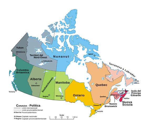
Italiano: Una mappa del Canada che mostra le dieci province e i tre territori, e le rispettive capitali. (Proiezione conica conforme di Lambert da The Atlas of Canada)
English: A map of Canada exhibiting its ten provinces and three territories, and their capitals. (Lambert conformal conic projection from The Atlas of Canada) |
||
| Date | |||
| Source |
This file was derived from: |
||
| Author | Indil77 | ||
| Other versions |
Derivative works of this file: |
||
| SVG development | This icon was created with Inkscape.
|
Licensing
| |
This work has been released into the public domain by its author, Indil77, at the English Wikipedia project. This applies worldwide. In case this is not legally possible: |
File history
Click on a date/time to view the file as it appeared at that time.
| Date/Time | Thumbnail | Dimensions | User | Comment | |
|---|---|---|---|---|---|
| current | 20:43, 13 December 2019 | | 512 × 443 (984 KB) | Indil77 | fix text issue |
| 20:38, 13 December 2019 |  | 512 × 443 (982 KB) | Indil77 | texts converted into path | |
| 20:20, 13 December 2019 |  | 512 × 443 (965 KB) | Indil77 | fix scala e testo non visibile | |
| 20:00, 13 December 2019 |  | 512 × 443 (956 KB) | Indil77 | fix spaziatura scala | |
| 19:56, 13 December 2019 |  | 512 × 443 (956 KB) | Indil77 | fix traduzione province e territori | |
| 19:45, 13 December 2019 |  | 512 × 443 (956 KB) | Indil77 | User created page with UploadWizard |
File usage
The following page uses this file:
Global file usage
The following other wikis use this file:
- Usage on als.wikipedia.org
- Usage on it.wikipedia.org