File:Minnesota population map.png
No higher resolution available.
Minnesota_population_map.png (600 × 600 pixels, file size: 163 KB, MIME type: image/png)
Summary
Taken from the English Wikipedia.
Original Description:
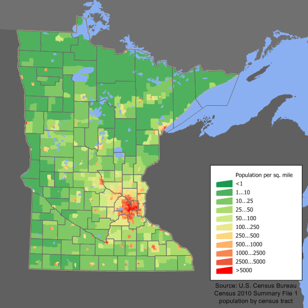
Minnesota population density map based on Census 2010 data. See the data lineage for the process description.
Original History:
22:34, 11 March 2006 . . JimIrwin (Talk | contribs) . . 560×470 (25,781 bytes) (Minnesota state population density map based on Census 2000 data. See the data lineage for a process description.)
Licensing

|
Permission is granted to copy, distribute and/or modify this document under the terms of the GNU Free Documentation License, Version 1.2 or any later version published by the Free Software Foundation; with no Invariant Sections, no Front-Cover Texts, and no Back-Cover Texts. A copy of the license is included in the section entitled GNU Free Documentation License. |
| This file is licensed under the Creative Commons Attribution-Share Alike 3.0 Unported license. | ||
| ||
| This licensing tag was added to this file as part of the GFDL licensing update. |
File history
Click on a date/time to view the file as it appeared at that time.
| Date/Time | Thumbnail | Dimensions | User | Comment | |
|---|---|---|---|---|---|
| current | 14:14, 11 December 2011 | | 600 × 600 (163 KB) | JimIrwin | 2010 census update |
| 16:59, 13 July 2009 |  | 560 × 470 (22 KB) | Falcorian | Lossless compression with pngout. | |
| 14:37, 16 September 2006 |  | 560 × 470 (25 KB) | Mortadelo2005 | Taken from the English Wikipedia.<br> Original Description:<br> ''Minnesota population density map based on Census 2000 data. See the data lineage for the process description.''<br> Original History:<br> '' |
File usage
The following page uses this file:
Global file usage
The following other wikis use this file:
- Usage on ca.wikipedia.org
- Usage on cy.wikipedia.org
- Usage on da.wikipedia.org
- Usage on de.wikipedia.org
- Usage on en.wikipedia.org
- Usage on es.wikipedia.org
- Usage on fr.wikipedia.org
- Usage on gl.wikipedia.org
- Usage on he.wikipedia.org
- Usage on pl.wikipedia.org
- Usage on ro.wikipedia.org
- Categorie:Statul Minnesota, SUA
- Saint Paul, Minnesota
- Categorie:Formate Minnesota
- Categorie:Liste Minnesota
- Categorie:Comitate din statul Minnesota, SUA
- Categorie:Lacuri din Minnesota
- Listă de oameni din statul Minnesota
- Categorie:Guvernul statului Minnesota
- Categorie:Sedii de comitate din Minnesota
- Categorie:Zone metropolitane din Minnesota
- Categorie:Zone micropolitane din Minnesota
- Categorie:Localități din Minnesota
- Categorie:Forme de relief din Minnesota
- Categorie:Comitatul Houston, Minnesota
- Categorie:Regiuni ale statului Minnesota
- Categorie:Comitatul Aitkin, Minnesota
- Categorie:Comitatul Anoka, Minnesota
- Categorie:Comitatul Beltrami, Minnesota
- Categorie:Comitatul Ramsey, Minnesota
- Categorie:Saint Paul, Minnesota
- Categorie:Dezastre naturale din statul Minnesota
- Bemidji, Minnesota
- Categorie:Membri ai legislaturii statului Minnesota
- Categorie:Localități din comitatul Olmsted, Minnesota
- Categorie:Geografia statului Minnesota după comitat
- Categorie:Localități din comitatul Ramsey, Minnesota
- Categorie:Absolvenți din Minnesota după instituția de învățământ superior
- Categorie:Geologia statului Minnesota
- Categorie:Oameni din statul Minnesota după ocupație
- Format:Sediile comitatelor din Minnesota
- Categorie:Localități din statul Minnesota riverane fluviului Mississippi
- Categorie:Localități din comitatul Beltrami, Minnesota
- Categorie:Geografia comitatului Beltrami, Minnesota
- Categorie:Geografia comitatului Olmsted, Minnesota
- Categorie:Geografia comitatului Ramsey, Minnesota
- Categorie:Târguri din statul Minnesota
- Categorie:Municipalități din statul Minnesota
View more global usage of this file.