File:Map of the Northern Cape with municipalities named and districts shaded (2016).svg

Size of this PNG preview of this SVG file: 589 × 600 pixels. Other resolutions: 236 × 240 pixels | 471 × 480 pixels | 754 × 768 pixels | 1,005 × 1,024 pixels | 2,010 × 2,048 pixels | 750 × 764 pixels.
Original file (SVG file, nominally 750 × 764 pixels, file size: 818 KB)
.svg)
Summary
| Description |
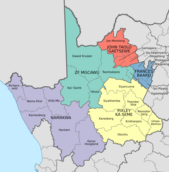
English: Map of the municipalities in the Northern Cape province of South Africa, with all municipalities named and district municipalities shaded different colours. |
| Date | |
| Source | Own work; based on File:Map of the Northern Cape with municipalities blank (2016).svg |
| Author | Htonl |
.svg)
Licensing
I, the copyright holder of this work, hereby publish it under the following licenses:
This file is licensed under the Creative Commons Attribution-Share Alike 3.0 Unported license.
- You are free:
- to share – to copy, distribute and transmit the work
- to remix – to adapt the work
- Under the following conditions:
- attribution – You must give appropriate credit, provide a link to the license, and indicate if changes were made. You may do so in any reasonable manner, but not in any way that suggests the licensor endorses you or your use.
- share alike – If you remix, transform, or build upon the material, you must distribute your contributions under the same or compatible license as the original.

|
Permission is granted to copy, distribute and/or modify this document under the terms of the GNU Free Documentation License, Version 1.2 or any later version published by the Free Software Foundation; with no Invariant Sections, no Front-Cover Texts, and no Back-Cover Texts. A copy of the license is included in the section entitled GNU Free Documentation License. |
You may select the license of your choice.
File history
Click on a date/time to view the file as it appeared at that time.
| Date/Time | Thumbnail | Dimensions | User | Comment | |
|---|---|---|---|---|---|
| current | 18:23, 4 February 2017 | | 750 × 764 (818 KB) | Htonl | == {{int:filedesc}} == {{Information |Description ={{en|1=Map of the municipalities in the Northern Cape province of South Africa, with all municipalities named and district municipalities shaded different colours.}} |Source ={{own}}; based... |
File usage
The following page uses this file:
Global file usage
The following other wikis use this file:
- Usage on en.wikipedia.org
- List of municipalities in the Northern Cape
- Government of the Northern Cape
- Template:Municipal elections in the Northern Cape
- Dikgatlong Local Municipality elections
- Ga-Segonyana Local Municipality elections
- Hantam Local Municipality elections
- Emthanjeni Local Municipality elections
- ǃKheis Local Municipality elections
- Dawid Kruiper Local Municipality elections
- Kamiesberg Local Municipality elections
- Magareng Local Municipality elections
- Kareeberg Local Municipality elections
- Gamagara Local Municipality elections
- Karoo Hoogland Local Municipality elections
- Kai !Garib Local Municipality elections
- Sol Plaatje Local Municipality elections
- Renosterberg Local Municipality elections
- Joe Morolong Local Municipality elections
- Kgatelopele Local Municipality elections
- Phokwane Local Municipality elections
- Siyancuma Local Municipality elections
- Khâi-Ma Local Municipality elections
- Tsantsabane Local Municipality elections
- Nama Khoi Local Municipality elections
- Siyathemba Local Municipality elections
- Richtersveld Local Municipality elections
- Thembelihle Local Municipality elections
- Ubuntu Local Municipality elections
- Umsobomvu Local Municipality elections
- Usage on frr.wikipedia.org
- Usage on fr.wikipedia.org
- Usage on pl.wikipedia.org
- Usage on zh.wikipedia.org
.svg)