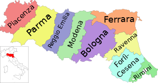
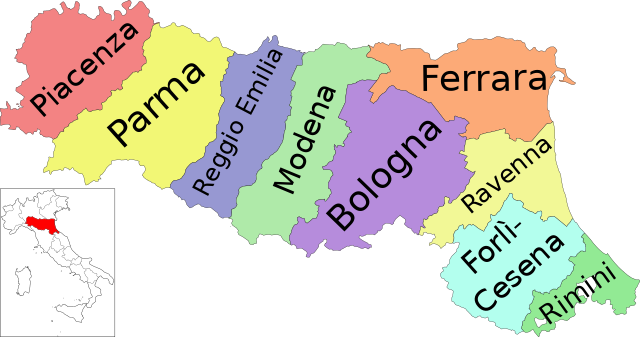
File:Map of region of Emilia-Romagna, Italy, with provinces-it.svg

Size of this PNG preview of this SVG file: 800 × 422 pixels. Other resolutions: 320 × 169 pixels | 640 × 337 pixels | 1,024 × 540 pixels | 1,280 × 675 pixels | 2,560 × 1,349 pixels | 4,800 × 2,530 pixels.
Original file (SVG file, nominally 4,800 × 2,530 pixels, file size: 186 KB)
Summary
| Description | (Italian version) |
| Date | |
| Source | Own work |
| Author | Vonvikken |
| Other versions |
    |


This W3C-unspecified vector image was created with Inkscape .
W3C-validity not checked.

|
This SVG file contains embedded text that can be translated into your language, using any capable SVG editor, text editor or the SVG Translate tool. For more information see: About translating SVG files. |
This vector image includes elements that have been taken or adapted from this file:
This vector image includes elements that have been taken or adapted from this file:
Licensing
| This work has been released into the public domain by its author, Vonvikken. This applies worldwide. In some countries this may not be legally possible; if so: |
File history
Click on a date/time to view the file as it appeared at that time.
| Date/Time | Thumbnail | Dimensions | User | Comment | |
|---|---|---|---|---|---|
| current | 06:19, 19 September 2023 | | 4,800 × 2,530 (186 KB) | Quetz72 | File uploaded using svgtranslate tool (https://svgtranslate.toolforge.org/). Added translation for ca. |
| 02:04, 7 October 2022 |  | 4,800 × 2,530 (186 KB) | Krepideia | Borders update: migration of the Municipalities of Montecopiolo and Sassofeltrio into the province of Rimini (2021) | |
| 23:31, 15 September 2010 |  | 4,800 × 2,530 (186 KB) | Vonvikken | +Minimap | |
| 22:26, 15 September 2010 |  | 4,800 × 2,530 (151 KB) | Vonvikken | == {{int:filedesc}} == {{Information |Description={{DescrMapRegionItaly|EMI|Italian}} |Source={{own}} |Author=Vonvikken |Date=2010-09-16 |Permission= |other_versions=100px|Blank[[File: |
File usage
The following 5 pages use this file:
Global file usage
The following other wikis use this file:
- Usage on an.wikipedia.org
- Usage on ar.wikipedia.org
- Usage on bg.wikipedia.org
- Usage on ca.wikipedia.org
- Usage on cs.wikipedia.org
- Usage on cy.wikipedia.org
- Usage on da.wikipedia.org
- Usage on de.wikipedia.org
- Usage on en.wikipedia.org
- Tiber
- Emilia-Romagna
- Provinces of Italy
- Province of Reggio Emilia
- Province of Bologna
- Province of Ferrara
- Province of Forlì-Cesena
- Province of Modena
- Province of Parma
- Province of Piacenza
- Province of Ravenna
- Category:Emilia-Romagna
- Province of Rimini
- Template:Emilia–Romagna
- Metropolitan City of Bologna
- List of municipalities of Emilia-Romagna
- Flag of Emilia-Romagna
- Altedo
- Monte Battaglia
- Citadel of Parma
- Usage on es.wikipedia.org
- Usage on et.wikipedia.org
- Usage on fi.wikipedia.org
- Usage on ga.wikipedia.org
- Usage on hu.wikipedia.org
- Usage on it.wikipedia.org
- Usage on it.wikibooks.org
- Usage on it.wikiversity.org
- Usage on ja.wikipedia.org
- Usage on lld.wikipedia.org
- Usage on lmo.wikipedia.org
View more global usage of this file.