File:Location Of Shelkovsky District (Chechnya, 2009).svg

Size of this PNG preview of this SVG file: 492 × 599 pixels. Other resolutions: 197 × 240 pixels | 394 × 480 pixels | 631 × 768 pixels | 841 × 1,024 pixels | 1,683 × 2,048 pixels | 6,295 × 7,662 pixels.
Original file (SVG file, nominally 6,295 × 7,662 pixels, file size: 1.13 MB)
.svg)
Summary
| Description |
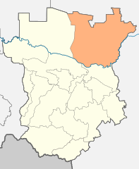
English: Image to indicate Chechen Republic districts. Subject as indicated by filename. |
| Date | |
| Source |
Own work This W3C-unspecified vector image was created with Inkscape . |
| Author | Виктор В |
Licensing
| I, the copyright holder of this work, release this work into the public domain. This applies worldwide. In some countries this may not be legally possible; if so: I grant anyone the right to use this work for any purpose, without any conditions, unless such conditions are required by law. |
File history
Click on a date/time to view the file as it appeared at that time.
| Date/Time | Thumbnail | Dimensions | User | Comment | |
|---|---|---|---|---|---|
| current | 22:32, 15 June 2021 | | 6,295 × 7,662 (1.13 MB) | Takhirgeran Umar | quality |
| 09:18, 22 January 2020 |  | 6,393 × 7,997 (4.76 MB) | Takhirgeran Umar | color | |
| 00:13, 22 January 2020 |  | 6,393 × 7,997 (4.76 MB) | Takhirgeran Umar | correction | |
| 19:32, 12 July 2010 |  | 618 × 774 (72 KB) | Виктор В | == {{int:filedesc}} == {{Information |Description={{en|1=Image to indicate Chechen Republic districts. Subject as indicated by filename.}} |Source={{own}} {{Inkscape}} Схема территориального планирования Чеченской |
File usage
The following page uses this file:
Global file usage
The following other wikis use this file:
- Usage on fi.wikipedia.org
- Usage on hu.wikipedia.org
- Usage on it.wikipedia.org
- Usage on nl.wikipedia.org
- Usage on pl.wikipedia.org
- Usage on sco.wikipedia.org
- Usage on zh-min-nan.wikipedia.org
.svg)