File:Indira Gandhi, Paris 1961.tiff

Size of this JPG preview of this TIF file: 434 × 600 pixels. Other resolutions: 174 × 240 pixels | 347 × 480 pixels | 556 × 768 pixels | 741 × 1,024 pixels | 1,482 × 2,048 pixels | 4,150 × 5,734 pixels.
Original file (4,150 × 5,734 pixels, file size: 68.57 MB, MIME type: image/tiff)
Summary
| Photographer |
|
||||||||||
| Description |
Français : Portrait d'une femme en sari assise dans un fauteuil. Elle a son sac à main posé sur ses genoux et regarde sur le côté |
||||||||||
| Depicted people | Indira Gandhi (Q1149) | ||||||||||
| Depicted place | World Heritage Centre (Q3279650), France (Q142) | ||||||||||
| Keywords | Women, Women in politics, Heads of state,International organizations, | ||||||||||
| Date | 1961 | ||||||||||
| Accession number |
PHOTO0000004876 |
||||||||||
| Inscriptions |
Français : Mme Indira Gandhi, Ministre de l'Information de l'Inde, Membre du Conseil exécutif de l'UNESCO |
||||||||||
| Archival code | 29.287 | ||||||||||
| Source |
|
||||||||||
| Permission (Reusing this file) |
This file is licensed under the Creative Commons Attribution-ShareAlike 3.0 IGO license. Attribution: UNESCO / Alexis N. Vorontzoff
|
||||||||||
| Other versions |
|
||||||||||


| Camera location | | View this and other nearby images on: OpenStreetMap |
|---|
File history
Click on a date/time to view the file as it appeared at that time.
| Date/Time | Thumbnail | Dimensions | User | Comment | |
|---|---|---|---|---|---|
| current | 20:27, 6 November 2020 | 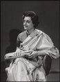 | 4,150 × 5,734 (68.57 MB) | AliciaFagervingWMSE-bot | pattypan 20.04 |
File usage
The following 2 pages use this file:
Global file usage
The following other wikis use this file:
- Usage on da.wikipedia.org
- Usage on en.wikipedia.org
- Usage on my.wikipedia.org
- Usage on roa-tara.wikipedia.org