File:Easter Island map-fr.svg

Size of this PNG preview of this SVG file: 800 × 569 pixels. Other resolutions: 320 × 228 pixels | 640 × 455 pixels | 1,024 × 729 pixels | 1,280 × 911 pixels | 2,560 × 1,821 pixels | 1,750 × 1,245 pixels.
Original file (SVG file, nominally 1,750 × 1,245 pixels, file size: 878 KB)
Summary
This image was selected as picture of the day on Wikimedia Commons for 1 December 2008. It was captioned as follows: English: Detailed topographic map in English of Easter Island. Other languages:
Afrikaans: Gedetaileerde topografie van Paaseiland Català: Mapa topogràfic detallat en anglès de l'Illa de Pasqua. Čeština: Detailní topografická mapa Velikonočního ostrova Eesti: Detailne inglisekeelne topograafiline kaart et:Lihavõttesaarest. English: Detailed topographic map in English of Easter Island. Esperanto: detala topografia mapo de la Paskinsulo (jen anglalingva, sed ankaŭ havebla en pluraj aliaj lingvoj) Français : Carte topographique détaillée en anglais de l'île de Pâques Italiano: Mappa topografica dell'Isola di Pasqua, Cile. Nederlands: Engelstalige gedetailleerde topografische kaart van Paaseiland Português: Mapa topográfico detalhado, em Inglês, da Ilha da Páscoa Română: Hartă topografică detaliată, în limba engleză, a insulei Paștelui. Svenska: Detaljerad topografisk karta på engelska över Påskön. Македонски: Детална топографска карта на Велигденскиот Остров на англиски. Русский: Топографическая карта Острова Пасхи 한국어: 이스터 섬의 지형도. 中文: 复活节岛地形图 中文(繁體): 復活節島地形圖 |
| Description |
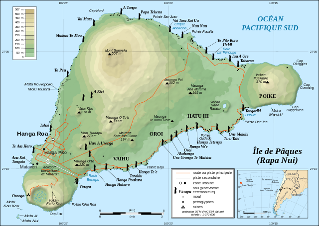
English: Topographic map in French of Easter Island.
Note: The shaded relief is a raster image embedded in the SVG file. Français : Carte topographique en français de l'île de Pâques. Note : les ombres du relief sont une image bitmap embarquée dans le fichier SVG.
|
||
| Date | November 2006 - October 2008 for the new version (see the release note) | ||
| Source |
Own work
|
||
| Author | Eric Gaba (Sting - fr:Sting) | ||
| Permission (Reusing this file) |
|
||
| Other versions |
Derivative works of this file:
[]
|


![[1]](http://www.waymarker.co.uk/ml/rapanui/map.jpg)
_location_map.svg)
This W3C-unspecified vector image was created with Inkscape .

|
This SVG file contains embedded text that can be translated into your language, using any capable SVG editor, text editor or the SVG Translate tool. For more information see: About translating SVG files. |
Licensing
I, the copyright holder of this work, hereby publish it under the following license:
This file is licensed under the Creative Commons Attribution-Share Alike 2.5 Generic license.
- You are free:
- to share – to copy, distribute and transmit the work
- to remix – to adapt the work
- Under the following conditions:
- attribution – You must give appropriate credit, provide a link to the license, and indicate if changes were made. You may do so in any reasonable manner, but not in any way that suggests the licensor endorses you or your use.
- share alike – If you remix, transform, or build upon the material, you must distribute your contributions under the same or compatible license as the original.
File history
Click on a date/time to view the file as it appeared at that time.
| Date/Time | Thumbnail | Dimensions | User | Comment | |
|---|---|---|---|---|---|
| current | 12:46, 22 April 2010 | | 1,750 × 1,245 (878 KB) | Naturals | Correction mot: Caleta => Crique |
| 12:39, 22 October 2008 |  | 1,750 × 1,245 (877 KB) | Sting | + scale | |
| 20:02, 21 October 2008 |  | 1,750 × 1,245 (876 KB) | Sting | Completely new version using other sources ; new standard colors | |
| 01:14, 30 October 2007 |  | 1,750 × 1,245 (537 KB) | Sting | Some additional info | |
| 13:52, 2 April 2007 |  | 1,750 × 1,245 (537 KB) | Sting | Bug fix (display of some layers) | |
| 02:34, 27 January 2007 |  | 1,750 × 1,245 (577 KB) | Sting | Colour standard | |
| 22:39, 23 November 2006 |  | 1,750 × 1,245 (470 KB) | Sting | Cosmetic text rendering correction | |
| 22:32, 23 November 2006 |  | 1,750 × 1,245 (470 KB) | Sting | Last (?) correction (thanks Sodipodi) | |
| 21:53, 23 November 2006 |  | 1,750 × 1,245 (432 KB) | Sting | Again (via Sodipodi) | |
| 21:16, 23 November 2006 |  | 1,750 × 1,245 (552 KB) | Sting | Again (plain svg) |
File usage
The following page uses this file:
Global file usage
The following other wikis use this file:
- Usage on ar.wikipedia.org
- Usage on az.wikipedia.org
- Usage on ba.wikipedia.org
- Usage on be.wikipedia.org
- Usage on ca.wikipedia.org
- Usage on cs.wikipedia.org
- Moai
- Pavel Pavel
- Velikonoční ostrov
- Rano Kau
- Orongo (Velikonoční ostrov)
- Anakena
- Rano Raraku
- Pukao
- Maunga Terevaka
- Poike
- Puna Pau
- Šablona:Velikonoční ostrov
- Jacob Roggeveen
- Katherine Routledge
- Hanga Roa
- Ahu Tongariki
- Ahu Akivi
- Ahu Vai Uri
- Ahu Ko Te Riku
- Ahu Nau Nau
- Maunga Orito
- Rano Aroi
- William Mulloy
- Motu Nui
- Národní park Rapa Nui
- Wikipedista:Pilgrim/Pokusy
- Georg Forster
- Ahu Te Pito Kura
- Rongorongo
- Tahai
- Ahu
- Felipe González Ahedo
- Thor Heyerdahl
- Kuchyně Velikonočního ostrova
- Reimiro
- Jean-Baptiste Dutrou-Bornier
- Usage on eo.wikipedia.org
- Usage on fi.wikipedia.org
- Usage on fr.wikipedia.org
View more global usage of this file.