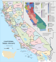
File:California tribes and languages at contact.svg

Size of this PNG preview of this SVG file: 543 × 600 pixels. Other resolutions: 217 × 240 pixels | 434 × 480 pixels | 695 × 768 pixels | 927 × 1,024 pixels | 1,854 × 2,048 pixels | 1,060 × 1,171 pixels.
Original file (SVG file, nominally 1,060 × 1,171 pixels, file size: 2.46 MB)
File history
Click on a date/time to view the file as it appeared at that time.
| Date/Time | Thumbnail | Dimensions | User | Comment | |
|---|---|---|---|---|---|
| current | 17:30, 29 December 2017 |  | 1,060 × 1,171 (2.46 MB) | Wereldburger758 | The text "Pacific Ocean", "Channel Islands", "Tulare Lake" and "Lake Cahuilla" is in blue now. |
| 06:40, 31 March 2014 |  | 1,060 × 1,171 (2.51 MB) | Wereldburger758 | Removal hidden element outside of picture. Vacuum defs for removal clippaths. Object to path of elements. Valid SVG now. Take a look at this page for instructions how to make SVG-files valid: https://commons.wikimedia.org/wiki/Help:SVG/basic1 | |
| 08:16, 13 September 2013 |  | 1,060 × 1,171 (1.14 MB) | Concerto | tweaks | |
| 09:49, 12 September 2013 |  | 1,060 × 1,171 (1.27 MB) | Concerto | Reverted to version as of 08:30, 12 September 2013 | |
| 09:45, 12 September 2013 |  | 1,060 × 1,171 (1.13 MB) | Concerto | saved in plain SVG | |
| 08:30, 12 September 2013 |  | 1,060 × 1,171 (1.27 MB) | Concerto | {{Information |Description ={{en|1=A map of California tribal areas and languages at the time of European contact. }} |Source ={{own}} {{Created with Inkscape |IMPORTANT=yes }} {{AttribSVG |1=USA California location map.svg }} {{AttribSVG |1... |
File usage
The following page uses this file:
Global file usage
The following other wikis use this file:
- Usage on de.wikipedia.org
- Usage on en.wikipedia.org
- Usage on oc.wikipedia.org
