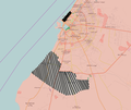
File:Benghazi Conflict Detailed Map.png

Original file (1,432 × 1,206 pixels, file size: 644 KB, MIME type: image/png)

This file is from Wikimedia Commons and may be used by other projects. The description on its file description page there is shown below.

Summary

Description
English: Benghazi Conflict Detailed map
English:
 
Under the control of the Tobruk-led Government and Libyan National Army
Date
Source Own work, after an edit from my original map from Ermanarich.
Author PutItOnAMap.
Other versions
Ongoing armed conflicts ( Countries Maps )
National or regional Maps of ongoing insurgencies, armed conflicts, disputes of territories, military conflicts, and also current civil or international wars :

Overview Maps:

National-wide Maps:

National-wide Maps of areas of activity:

Note: Comments "areas of activity" means that this is not territorial control is shown.

Sub-national-wide Maps:

See also:
Category:Conflicts in 2024 (with list of countries in ongoing armed conflicts)
Template:City maps of ongoing civil wars (Local maps)

Ongoing armed conflicts ( Local & City Maps )

Licensing

w:en:Creative Commons
attribution
This file is licensed under the Creative Commons Attribution 2.5 Generic license.
You are free:
  • to share – to copy, distribute and transmit the work
  • to remix – to adapt the work
Under the following conditions:
  • attribution – You must give appropriate credit, provide a link to the license, and indicate if changes were made. You may do so in any reasonable manner, but not in any way that suggests the licensor endorses you or your use.

Captions

Add a one-line explanation of what this file represents

Items portrayed in this file

depicts

26 April 2016

image/png

853e37dd9af3d5522c8a558789c4552bdd173207

659,837 byte

1,206 pixel

1,432 pixel

File history

Click on a date/time to view the file as it appeared at that time.

Date/TimeThumbnailDimensionsUserComment
current12:05, 26 April 2016Thumbnail for version as of 12:05, 26 April 20161,432 × 1,206 (644 KB)PutItOnAMapImproved marking of different factions.
12:04, 26 April 2016Thumbnail for version as of 12:04, 26 April 20161,432 × 1,206 (644 KB)PutItOnAMapImproved marking of different factions.
22:49, 23 April 2016Thumbnail for version as of 22:49, 23 April 2016815 × 1,049 (548 KB)PutItOnAMapUser created page with UploadWizard

Global file usage

The following other wikis use this file:

Metadata