File:Azerbaijan districts numbered.png
Azerbaijan_districts_numbered.png (499 × 396 pixels, file size: 34 KB, MIME type: image/png)

|
This locator map image could be re-created using vector graphics as an SVG file. This has several advantages; see Commons:Media for cleanup for more information. If an SVG form of this image is available, please upload it and afterwards replace this template with
{{vector version available|new image name}}.
It is recommended to name the SVG file “Azerbaijan districts numbered.svg”—then the template Vector version available (or Vva) does not need the new image name parameter. |
| Description |
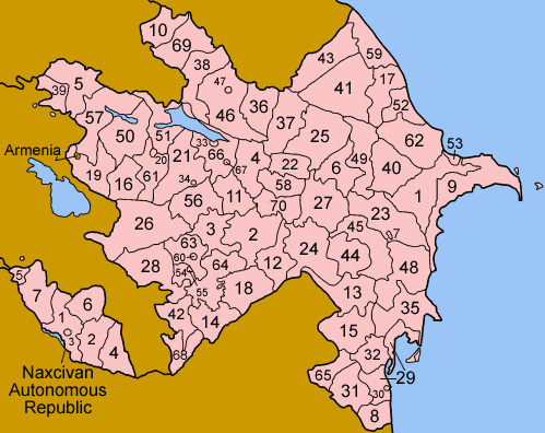
Map of the rayans and sahars (cities) of Azerbaijan, numbered in Azerbaijani alphabetical order. The former Nagorno-Karabakh Autonomous Oblast (and the self-proclained Nagorno-Karabakh Republic) is shown in pale green; two rayons, 26 (Kalbajar) and 56 (Tartar) are both partly in Nagorno-Karabakh, the rest in the green area are completely in Nagorno-Karabakh. The entire territory controlled by Armenian forces is shown in pale yellow. The southern portion of 21 (Goranboy) is claimed by the Nagorno-Karabakh Republic, but it was not part of the Nagorno-Karabakh Autonomous Oblast, and is not reflected in this map. Some of the borders of the divisions of Nagorno-Karabakh are different from the official ones used by Azerbaijan; please see Image:Nagorno-Karabakh regions named english.png for a more detailed view of the area. List is in english, with Azerbaijani name following in parentheses if different from English.
The six rayons and one city of the Nakhichevan Autonomous Republic are listed and numbered separately. |
| Date | |
| Source | Self-made, traced from public domain UN or CIA maps, referencing various Azerbaijani sources. |
| Author | User:Golbez |
| Permission (Reusing this file) |
Provide attribution, please. See below. |
- You are free:
- to share – to copy, distribute and transmit the work
- to remix – to adapt the work
- Under the following conditions:
- attribution – You must give appropriate credit, provide a link to the license, and indicate if changes were made. You may do so in any reasonable manner, but not in any way that suggests the licensor endorses you or your use.
- share alike – If you remix, transform, or build upon the material, you must distribute your contributions under the same or compatible license as the original.

|
Permission is granted to copy, distribute and/or modify this document under the terms of the GNU Free Documentation License, Version 1.2 or any later version published by the Free Software Foundation; with no Invariant Sections, no Front-Cover Texts, and no Back-Cover Texts. A copy of the license is included in the section entitled GNU Free Documentation License. |
| This file is licensed under the Creative Commons Attribution-Share Alike 3.0 Unported license. | ||
| ||
| This licensing tag was added to this file as part of the GFDL licensing update. |
File history
Click on a date/time to view the file as it appeared at that time.
| Date/Time | Thumbnail | Dimensions | User | Comment | |
|---|---|---|---|---|---|
| current | 10:51, 31 October 2023 | | 499 × 396 (34 KB) | Wertuose | Nagorno-Karabakh no more exists in that territories. |
| 13:46, 9 April 2021 |  | 750 × 595 (59 KB) | Mahammad tt | Reverted to version as of 09:11, 25 March 2006 (UTC) | |
| 12:50, 5 August 2015 |  | 750 × 595 (191 KB) | Szczureq | Entire Armenian-controlled territory highlighted in yellow | |
| 09:11, 25 March 2006 |  | 750 × 595 (59 KB) | Golbez | Updated version adding Kangarli, better borders (particularly for Ali Bayramli and Absheron), and softer color for Nagorno-Karabakh to match the individual maps. | |
| 22:56, 24 December 2005 |  | 750 × 595 (59 KB) | Golbez | Updated version showing Nagorno-Karabakh | |
| 05:59, 21 January 2005 |  | 499 × 396 (34 KB) | Golbez | Fixed version; two numbers were incorrect | |
| 09:55, 2 January 2005 |  | 499 × 396 (34 KB) | Golbez | Newer, cleaner version | |
| 04:42, 23 December 2004 |  | 500 × 410 (92 KB) | Rmhermen | Map of Azerbaijan showing rayons and other districts. Made by User:Golbez. {{cc-by-sa-2.0}} | |
| 02:10, 20 December 2004 |  | 500 × 410 (38 KB) | Golbez | Version with Naxcivan noted | |
| 01:49, 20 December 2004 |  | 500 × 410 (38 KB) | Golbez | Map of Azerbaijan showing rayons and other districts. Made by User:Golbez. {{cc-by-sa-2.0}} |
File usage
The following 2 pages use this file:
Global file usage
The following other wikis use this file:
- Usage on af.wikipedia.org
- Usage on ami.wikipedia.org
- Usage on arz.wikipedia.org
- Usage on azb.wikipedia.org
- قوبادلی رایونو
- آغدام رایونو
- جبراییل رایونو
- کلبجر رایونو
- آغجابهدی رایونو
- آغداش رایونو
- آغسو رایونو
- فوضولی رایونو
- گؤیگؤل رایونو
- بئیلقان رایونو
- داشکسن رایونو
- قبهله رایونو
- اوغوز رایونو
- شاماخی رایونو
- بیلهسووار رایونو
- گؤیچای رایونو
- حاجی قبول رایونو
- زنگیلان رایونو
- زاقاتالا رایونو
- یئولاخ رایونو
- گدهبی رایونو
- لنکران رایونو
- لاچین رایونو
- شوشا رایونو
- ایسماعیللی رایونو
- آستارا رایونو
- برده رایونو
- زرداب رایونو
- یاردیملی رایونو
- خوجاوند رایونو
- خیزی رایونو
- اوجار رایونو
- توووز رایونو
- ترتر رایونو
- سیهزن رایونو
- شکی رایونو
- ساموخ رایونو
- سالیان رایونو
- شابران رایونو
- صابیرآباد رایونو
- ساعاتلی رایونو
- قاخ رایونو
- نفتچالا رایونو
- ماساللی رایونو
- لریک رایونو
- کوردمیر رایونو
- گورانبوی رایونو
View more global usage of this file.