File:Angkor Kambodscha Karte.png

Angkor_Kambodscha_Karte.png(527 × 522 pixels, file size: 47 KB, MIME type: image/png)

This file is from Wikimedia Commons and may be used by other projects. The description on its file description page there is shown below.

Description
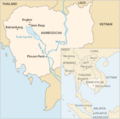
Deutsch: Lage von Angkor in Kambodscha.
English: Map of Cambodia — showing Angkor, and the routes of the Tonlé Sap and Mekong rivers.
Date 20 July 2004 (original upload date)
Source Transferred from de.wikipedia to Commons using CommonsHelper.
Author Tsui at German Wikipedia

Licensing

Public domain This work has been released into the public domain by its author, Tsui at German Wikipedia. This applies worldwide.
In some countries this may not be legally possible; if so:
Tsui grants anyone the right to use this work for any purpose, without any conditions, unless such conditions are required by law.

Original upload log

The original description page was here. All following user names refer to de.wikipedia.
  • 2004-07-20 17:55 Tsui 527×522× (38906 bytes) KArte

Original upload log

Date/Time Dimensions User Comment
23 November 2010, 21:02:59 527 × 522 (38906 bytes) File Upload Bot (Magnus Manske) (talk · contribs) {{BotMoveToCommons|de.wikipedia|year={{subst:CURRENTYEAR}}|month={{subst:CURRENTMONTHNAME}}|day={{subst:CURRENTDAY}}}} {{Information |Description={{de|Lage von '''[[:de:Angkor|]]''' in [[:de:Kambodscha|]] siehe auch: ''[[:de:Tonle Sap See|]], [[:de:Süd

Captions

Add a one-line explanation of what this file represents

Items portrayed in this file

depicts

20 July 2004

image/png

cd3ce36612e04db095e03d202023dc0ff6a3ea2a

48,067 byte

522 pixel

527 pixel

File history

Click on a date/time to view the file as it appeared at that time.

Date/TimeThumbnailDimensionsUserComment
current22:37, 21 September 2018Thumbnail for version as of 22:37, 21 September 2018527 × 522 (47 KB)PeteremuellerRS
17:59, 5 March 2017Thumbnail for version as of 17:59, 5 March 2017527 × 522 (38 KB)BjsPhú Quốc is part of Vietnam
08:43, 14 April 2015Thumbnail for version as of 08:43, 14 April 2015527 × 522 (32 KB)RokerHROoptipng -o7 -i0 → 18.35% decrease
16:33, 16 August 2014Thumbnail for version as of 16:33, 16 August 2014527 × 522 (39 KB)GifTaggerBot: Converting file to superior PNG file. (Source: Angkor_Kambodscha_Karte.gif). This GIF was problematic due to non-greyscale color table.

The following page uses this file:

Global file usage

The following other wikis use this file:

Metadata