File:Afghanistan-Konar.png
No higher resolution available.
Afghanistan-Konar.png (300 × 230 pixels, file size: 9 KB, MIME type: image/png)
Summary
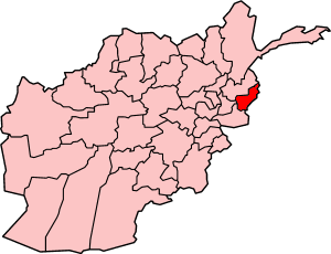
Map of Afghanistan showing Konar province. Made by User:Golbez, based on original map by Morwen on en.wikipedia.
Licensing

|
Permission is granted to copy, distribute and/or modify this document under the terms of the GNU Free Documentation License, Version 1.2 or any later version published by the Free Software Foundation; with no Invariant Sections, no Front-Cover Texts, and no Back-Cover Texts. A copy of the license is included in the section entitled GNU Free Documentation License. |
| This file is licensed under the Creative Commons Attribution-Share Alike 3.0 Unported license. | ||
| ||
| This licensing tag was added to this file as part of the GFDL licensing update. |
File history
Click on a date/time to view the file as it appeared at that time.
| Date/Time | Thumbnail | Dimensions | User | Comment | |
|---|---|---|---|---|---|
| current | 04:54, 29 September 2005 | | 300 × 230 (9 KB) | Golbez | Map of Afghanistan showing Konar province. Made by User:Golbez, based on original map by Morwen on en.wikipedia. ==Licensing== {{self|cc-by-2.5}} |
File usage
The following page uses this file:
Global file usage
The following other wikis use this file:
- Usage on ar.wikipedia.org
- Usage on bn.wikipedia.org
- Usage on en.wikipedia.org
- Marawara District
- Marawara
- Bar Kunar District
- Dangam District
- Nari District
- Ghaziabad District, Kunar
- Shaigal District
- Watapur District
- Chapa Dara District
- Narang Badil District
- Chawkay District
- Nurgal District
- Nur Gal
- Khas Kunar District
- Sirkanay District
- Asmar, Afghanistan
- Qari Ziaur Rahman
- Template:Kunar-geo-stub
- Mangwal, Afghanistan
- Dara-I-Pech District
- Death of Linda Norgrove
- Chalas
- Ghaziabad, Kunar
- Mano Gai
- COP Badel
- Chapa Dara
- Shultan District
- Usage on fa.wikipedia.org
View more global usage of this file.