File:1947 Nanhai Zhudao.png
Original file (2,654 × 3,840 pixels, file size: 4.42 MB, MIME type: image/png)
 This media file has been nominated for deletion since 13 February 2024. To discuss it, please visit the nomination page.
Do not remove this tag until the deletion nomination is closed. Reason for the nomination: No source link and no license link. On bottom of file is nansha.org.cn - but this
| |||
| |||
Summary
| Description |
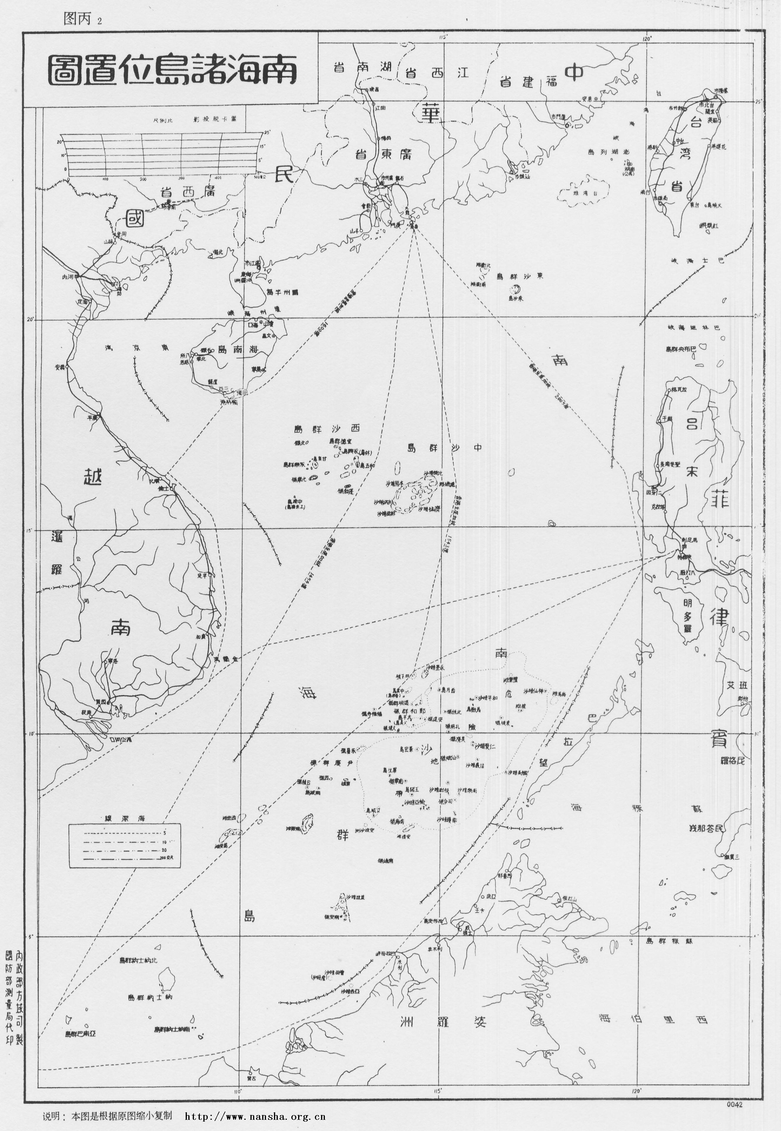
English: Location Map of South China Sea Islands, Secretariat of Government of Guangdong Province. January, 1947.
Left margin written as: Made by Territory Department of Ministry of the Interior, printed by Bereau of Surveying of Ministry of Defence. Now in Sun Yat-sen Library of Guangdong Province, China, this map describes Dongsha Islands, Xisha Islands and Zhongsha Islands in details. Every island has its name in Chinese and English, with depth of sea marks and descriptions as following: "November of 35th year of the Republic (A.D. 1946), Executive Yuan ordered the Navy Command Headquarter and Ministry of the Interior to assist Guangdong government to accept Nanhai Zhudao: ROCS Taiping, ROCS Zhongye to accept Tuansha Qundao, ROCS Yongxing, ROCS Zhongjian to accept Xisha Qundao. The mission is completed in December of the same year. In honor of the actions of Taiping Ship and Yongxing ship, Chang Island (長島) is renamed to Taiping Island (太平島), and the Lin Island (林島) is renamed to Yongxing Island (永興島) under orders. The Xiniao Island (西鳥島) is also called Spratly Island. Because it is located in the far south, so the Goverment renames it to Nanwei Island (南威島). The Ministry of the Interior adjusted the names of the islands according to their locations in the South China Sea, so changed Tuansha Islands (團沙群島) (i.e. Xinnan Islands (新南群島) by Japanese, Spratly Islands by Westerners) to Nansha Islands (南沙群島), and the former Japanese Nansha Islands (南沙群島) is renamed to Zhongsha Islands (中沙群島). The other islands and reefs are named after the historical diplomats to the Nanyang, in memory of them."中文:《南海諸島位置圖》1947年正月广东省政府秘书处编制。左侧写明:内政部方域司制,国防部测量局代印。现藏于广东省立中山图书馆。
图中详绘了东沙群岛、西沙群岛、中沙群岛,各岛屿有中英对照,海标均有深度,并附有说明: “中华民国三十五年十一月,行政院令海军总司令部、内政部协助广东省政府接收南海诸岛,并派太平舰、中业舰接收团沙群岛,永兴舰、中建舰接收西沙群岛, 同年十二月任务完成,为纪念太平舰、永兴舰之行之盛举,奉命将长岛改名为太平岛,林岛改名为永兴岛。本府以西鸟岛又名斯巴特列岛,远处南疆,特改为南威岛。 内政部为调整各群岛名称,复将团沙群岛(即日人所称之“新南群岛”,西人所称之Spratly群岛)改为南沙群岛,原曰之南沙群岛则改为中沙群岛, 以符诸岛在南海所处之位置。其余各岛洲礁多以历朝出任南洋使节之名以名之,以志纪念焉。” |
| Date | |
| Source |
Made by Territory Department of Ministry of the Interior, printed by Bereau of Surveying of Ministry of Defence. Now in Sun Yat-sen Library of Guangdong Province, China, this map describes Dongsha Islands, Xisha Islands and Zhongsha Islands in details. Every island has its name in Chinese and English, with depth of sea marks and descriptions as following: |
| Author | Secretariat of Government of Guangdong Province, Republic of China |
This image is now in the public domain in China because its term of copyright has expired. According to copyright laws of the People's Republic of China (with legal jurisdiction in the mainland only, excluding Hong Kong and Macao), amended November 11, 2020, Works of legal persons or organizations without legal personality, or service works, or audiovisual works, enter the public domain 50 years after they were first published, or if unpublished 50 years from creation. For photography works of natural persons whose copyright protection period expires before June 1, 2021 belong to the public domain. All other works of natural persons enter the public domain 50 years after the death of the creator. To uploader: Please provide where the image was first published and who created it or held its copyright.
|
  |
This work is in the public domain in the United States because it meets three requirements:
For background information, see the explanations on Non-U.S. copyrights.
Note: This tag should not be used for sound recordings. |
File history
Click on a date/time to view the file as it appeared at that time.
| Date/Time | Thumbnail | Dimensions | User | Comment | |
|---|---|---|---|---|---|
| current | 11:52, 6 May 2008 | | 2,654 × 3,840 (4.42 MB) | Shibo77 | 说明:1947 《南中国海图》1947年正月广东省政府秘书处编制。 图中详绘了东沙群岛、西沙群岛、中沙群岛,各岛屿有中英对照,海标均有深度,并附有说明。 中华民国三十五年十一月,行政院� |
File usage
The following 2 pages use this file:
Global file usage
The following other wikis use this file:
- Usage on en.wikipedia.org
- Spratly Islands
- South China Sea Islands
- Scarborough Shoal
- Spratly Islands dispute
- Nine-dash line
- South China Sea Arbitration
- Template:Did you know nominations/Philippines v. China
- Wikipedia:Featured picture candidates/March-2014
- Wikipedia:Featured picture candidates/1947 Nanhai Zhudao
- 2016 in the Philippines
- Timeline of the South China Sea dispute
- Usage on en.wiktionary.org
- Usage on fr.wikipedia.org
- Usage on fr.wiktionary.org
- Usage on id.wikipedia.org
- Usage on it.wikipedia.org
- Usage on ja.wikipedia.org
- Usage on ko.wikipedia.org
- Usage on no.wikipedia.org
- Usage on pl.wikipedia.org
- Usage on tl.wikipedia.org
- Usage on vi.wikipedia.org
- Usage on vi.wiktionary.org
- Usage on zh.wikipedia.org
- Usage on zh.wikinews.org
- Usage on zh.wikivoyage.org